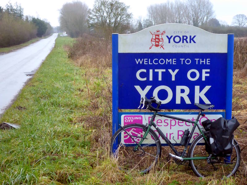
Stir-crazy from deskwork and gloomy weather, I got out today for a micro-adventure: an End to End of the City of York. At barely 14 miles long – from the northern extremity near Strensall, to the southern limit by Naburn – it vies for the title of ‘shortest End to End I’ve done’ with that of Liechtenstein, which I did last year.
Like the traverse of the mittel-european principality, York’s top to bottom is totally flat and runs mainly alongside a river (the Ouse, rather than the Rhine). However, it’s not quite so scenically fringed by mountains. More like waterlogged fields; today, anyway.
I’m talking the ‘City of York’, of course: the Unitary Authority of 1996. It’s the ‘county’ level drop-down for ‘York’ on web address forms: a roughly ten-by-ten-mile blob that’s home to 202,000 people, including me.
(Matters of transport, police and business, though not regular stuff like bins and libraries, will soon be devolved to the incoming mayor of York and North Yorkshire this spring. This means that, instead of the council ignoring cyclists and pandering to the car lobby, the mayor will, instead.)

Anyway, today I rode the ‘county of York’ End to End. The topmost point is on a country lane just northeast of Strensall, but doesn’t have a ‘Welcome to York’ sign.
For that particular photo-opportunity I rode a mile or so to Strensall itself: to the main road, whose boundary offers one. According to it, York is a ‘Cycling City’. Or at least, it was in 2007 when the sign was put up. Hmm. Perhaps we should append the words ‘Not really a…’ and ‘…any more’ to that.

Still, it wasn’t raining, I was on a bike at last after the Christmas/New Year lacuna, which I always think sounds more like a South American beast of burden, and I was beginning another joyful little cycling experience.
Strensall is a barracks village, which may explain the presence of two pubs in such a small place, and has a common just up the road. Unlike the south people don’t simply avoid you here, though I would have much preferred it that way, as they were driving a 4×4 too fast and too close to me at the time.

So I headed to Haxby, another ‘village’ which really feels like a small, friendly, compact town. (It has two named shopping centres, four pubs within ambling distance, several cafes and two large supermarkets.)
I nipped into Haxby Bakehouse for a focaccia, the sort of thing that might have bewildered my grandparents, unsure whether to eat it, ask the doctor about it, or tell you off for being foul-mouthed.

Haxby is a lovely place, but would be lovelier if the road to York wasn’t so full of impatient drivers. After several close passes I muttered that they should go and get focaccia.
New Earswick, just north of central York, is a village associated with the Rowntree dynasty, Quaker confectioners who pioneered responsible business with both customer and worker welfare in mind.

The model 19th-century village benefits from modest but decent housing, and roads named after trees originally planted with those trees: Lime Tree Avenue, Almond Grove, Hazel Close and so on. Not all those trees survived though. So for instance there aren’t any station trees in Station Avenue. Or indeed a station.
A slight drawback of the Quaker background is the lack of a pub in New Earswick. But on the plus side, there’s a splendid library and Folk Hall with a Rowntree-supported cafe for local residents (some with special needs) where we often eat very well and for very good prices.

From here I rolled along the car-free cycle path that follows the old Beverley rail line, axed by Beeching, and over Bootham to join the riverside cycle path by the railway station.

Except I couldn’t, of course, because recent floods (over the 4m level) made the path impassable. York’s centre is inundated pretty regularly by the Ouse these days, with the riverside cycleways out of action for maybe three or four weeks of the year.

So, after I swung past the wonderful Minster, I had to take road alternatives to the waterside path by going down Bishopthorpe Road.

‘Bishy Rd’ is the cool place for professionals in York, with its indie shops and cafes and general vibe. If you read the Guardian, or in fact if you read anything that’s not on a mobile phone screen, this is a place you will enjoy.

I rejoined the cycle path at the Knavesmire racecourse. Yorkshire has nine, two of which (here and in Pontefract) you can cycle round. I didn’t do that today, but carried on to the Planets Trail, an outstanding cycle path that links York to Selby along the old East Coast Main Line railway.

This was an easy trundle south, past scale models of the Sun, Mercury, Venus, Earth (and Moon), Mars, Jupiter, Saturn, Uranus, and – somewhere between that and Neptune, at Moreby Wood – the unmarked southern limit of the City of York.

Normally there’s little to see on either side of the path apart from unremarkable flat fields, but today – thanks to those floods – there was a giant lake.

So, there you are: Climate Change produces both winners (wading birds) and losers (everyone else including us). Swings and roundabouts.

Anyway, that was the End to End. I turned around and pedalled back home, stopping off for a coffee at the Brunswick Cafe, somewhere in the asteroid belt near Jupiter. I’m not sure this End to End quite ranks with others I’ve done like say Cuba or Sri Lanka, but it was fun.

Despite all that standing water, it was all plain sailing. Though I’d rather been hoping for more of the cycling, and less of the sailing.
